The municipality of Olešná makes an integral part of the Beskydy Euroregion that consists of municipalities and cities of the Slovak, Czech and Polish republics.
The village covering the area of 19 km² lies at an altitude of 470 meters, halfway between the district town of Čadca and the centre of the upper part of Kysuce- the town of Turzovka. It is adjacent to the municipalities of Staškov, Podvysoká, Turzovka, Klokočov and the municipality of Horní Lomná in the Czech Republic.
The municipality consists of two territorially separate parts, which is a rarity. For many years, these parts were called Olešná I and Olešná II but since February 7, 2003, by decision of the Office of Geodesy, Cartography and Cadastre in Bratislava, the cadastral parts are called Olešná and Olešná - Burkov vrch (Burkov Hill).
Burkov Hill - 1,031 meters above sea level on the border with the Czech Republic is the highest point of the village. Olešná - Burkov vrch is a part of the Kysuce Protected Landscape Area which was declared in 1984 and is territorially related to the Beskydy Protected Landscape Area (1973) in Moravia.
Sights:
- Olešňanský Klin Chapel (on Murínkov vrch)
- Olešná mosses
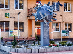
- Memorial to the victims of WWI and WWII
Cover photo of the monument: Jaroslav Cabadaj