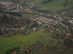
 The municipality of Podvysoká is a part of the Beskydy Euroregion formed by the municipalities and cities of the Slovak, Czech and Polish Republics. The village covering the area of 5.61 km² lies at an altitude of 460 meters, between the village of Staškov and the centre of the upper part of Kysuce - Turzovka.
The village was established in the first half of the 17th century during the time of Wallachian colonization. In historical records, it has been mentioned since 1658 under various names such as Podvysoká, Podvisoká in 1662, Podvysoka in 1690, Podviszoka, Határújfalu in Hungarian. It belonged to the estate of Budatín and Strečno.
The village was named Podvysoká because more than half of its area lies below the hill Vysoká. This name of the village was used only in written records and in official communication. The inhabitants of the region, who lived in settlements and hamlets scattered around the centre name the newly established village Nová Dedina.
The traditional events of the village include May feast, a football tournament, competitions of voluntary firefighting teams, a tennis tournament, and a meeting with pensioners.
Tourism and cycling:
Blue marked cycling route no. 2402 passes through the village - Staškov - Vysoká nad Kysucou.